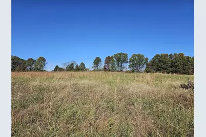
This is a carousel with tiles that activate property listing cards. Use the previous and next buttons to navigate.

$195,000 -$4,000 (-2.01%) Price Reduced
This is a carousel with tiles that activate property listing cards. Use the previous and next buttons to navigate.

Full Property Details for 133 Spoonbill Ln
General
- Price: $195,000
- HOA FEE: $8/month
- HOA FEE FREQ.: Annually
- Taxes: $169 (2023)
- Status: Active
- Type: Lots/Land
- Source: MARIS
- MLS ID: 24068738
- Updated: 12/17/2024
- Added to Site: 49 day(s) ago
Location
- Area: Wentzville-Timberland
- County: St Charles
- Township: Unincorporated
- Subdivision: Creekside Farms
- Cross Streets: S. Pointe Prairie
- Driving Directions: Hwy N to S. Point Prairie Road to Rt on Spoonbill
- Total Lots Available: 1
School Information
- School District: Wentzville R-IV
- High School District: Wentzville R-IV
- Elementary School: Boone Trail Elem.
- Middle School: Wentzville South Middle
- High School: Timberland High
Utilities
- Sewer: None
- Water: None
- Utility Description: Electricity Available, Gas to Site
Additional Structures
- Other Structures: None
Lot Features
- Lot Size (Acres): 3.47
- Lot Size (Sq. Ft.): 151,153
- Lot Size Source: County Records
- Lot Dimensions: see plot plan
- Frontage: Road/Right Of Way, Utility, County Road, Paved Streets
- Street/Road Desc.: Asphalt
- Topography: Level Lot, Level to Gently Roll, Open
- Lot Features: Backs to Trees/Woods, Cul-De-Sac, Level Lot
- Development Status: Finished Lot(s), Plat Recorded
- Zoning: SF
Financial Considerations
- Association Fee: $100
- Assoc Fee Freq.: Annually
- Tax Amount: $169
- Tax Year: 2023
- Terms: Cash Only, Conventional, VA
Disclosures and Reports
- Ownership: Private
- Special Conditions: None
- Documents Avail.: Legal Description, Soil Engineering Rpt
- Disclosures/Reports: Unknown, Agent Owned, Code Compliance Reqd, Flood Plain No, Unincorporated, Vacant Land
- Property ID: 4-0040-D217-00-0009.0000000
- Lot Number: 9
Listed by Berkshire Hathaway Alliance
Schools serving 133 Spoonbill Ln
| Rating | Name | Grades | Distance |
|---|---|---|---|
|
555 E Highway N, Wentzville, MO 63385 | K-6 | 3.6 mi | |
|
561 E Highway N, Wentzville, MO 63385 | 7-8 | 3.7 mi | |
|
559 E Highway N, Wentzville, MO 63385 | 9-12 | 3.7 mi |
Price & Sales History for 133 Spoonbill Ln
Estimate the Cost for 133 Spoonbill Ln
133 Spoonbill Lane, Foristell, MO 63348 (MLS# 24068738) is a Lots/Land property with a lot size of 3.47 acres. 133 Spoonbill Lane is currently listed for $195,000 and was received on November 01, 2024. Want to learn more about 133 Spoonbill Lane? Do you have questions about finding other Lots/Land real estate for sale in Foristell? You can browse all Foristell real estate or contact a Coldwell Banker agent to request more information.


